LIDAR: Bringing Heritage Places into the Digital Age
3D Mapping of Submarines, Structures, Landscapes and More
Tim Smith
Executive Director, Heritage Victoria
LIDAR (Light Detection and Ranging) is a surveying method that measures the distance to a target object through illumination with a laser light. It is used to make high-resolution, three-dimensional maps, with applications in deodesy, geomatics, archaeology, geography, geology, atmospheric physics and much more. In 2016, the Royal Society of Victoria heard from Young Scientist Research Prize winner, Yang Chen on her use of LIDAR to measure and map forest fuel loads to inform landscape and fire risk management in Victoria.
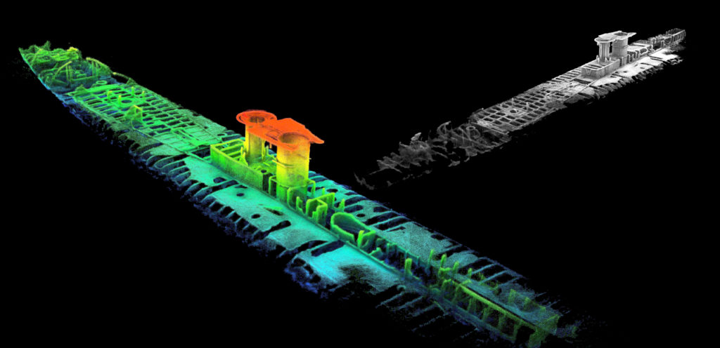
Heritage Victoria has put LIDAR technology to good use through a range of recent projects aimed at accurately mapping our heritage places for a 21st century audience. Working with CSIRO and their Zebedee LIDAR scanning system, Heritage Victoria has modelled sites from the Royal Exhibition Building, Murtoa Stick shed at Horsham, to World War One submarine shipwrecks in Port Phillip Bay. Come along and see the remarkable application of some of this technology to help the management and public engagement with some of our key State significant heritage places; particularly those that are harder to access for most people! Some inventive 3D modelling of overseas heritage places from Cambodia to the AE2 submarine wreck site (1915) near Gallipoli will also be included.
About the Speaker:
Tim Smith is the Executive Director of Heritage Victoria located within the Department of Environment, Land, Water & Planning in Melbourne. Tim manages a team of 33 heritage specialists, implements the provisions of the State Heritage Act 1995 and Commonwealth Historic Shipwrecks Act 1976 in Victoria, and delivers the Victorian Government’s $30M Living Heritage Grants program.
With over 25 years experience working in the Government heritage sector, he has specialty expertise in managing teams, media and public engagement, field practice and policy, defence and moveable heritage, State Government property asset management, and web/publications delivery. He is a recognised expert in his specialty field of maritime archaeology (Commonwealth Historic Shipwrecks Delegate), and has an extensive background in both Federal and State Government liaison, Ministerial and stakeholder consultation, legislation and compliance, grants, and in supporting the business of peak bodies such as the Heritage Council.
In a private capacity, Tim has a longstanding involvement in international archaeological projects in the Middle East, Turkey, Greece and Italy. He has led private projects mapping the underwater battlefield cultural landscape at Gallipoli, Turkey, and is a member of both the AE2 (1915) expedition safeguarding Australia’s Gallipoli submarine in the Dardanelles, and the search for the AE1 lost off Papua New Guinea (1914). A past leader of the internationally recognised project managing the 1942 Japanese midget submarine wreck M24 at Sydney (2006-13), Tim has been awarded a UNESCO Award of Distinction for heritage management and is a Member of ICOMOS.